Learn how the landscaped was shaped at Shepley.
Starting in Shepley Village centre, next to Cliff House, you are currently stood on the Grenoside sandstone, on which the entire village is built. This unit is about 20 meters thick, and is finely bedded. This means that when you see dry stone walls, or even some of the older farm buildings that are made of thin flag stones, the material was probably quarried here (we can see this later in the walk), before higher grade millstone grit was imported from further afield. The building material can therefore be useful as an indicator of age.
Walking east past the school, you will come across the granite war memorial, with the striking white colouration coming from the very large feldspar and quartz crystals. Granite is an igneous rock, which immediately tells us that this rock has been imported from a great distance away, as there are no igneous or metamorphic rocks in West Yorkshire.
When you reach Car Lane, you are now standing on the Penistone flags that have been quarried just over the road. You can also see the existing quarry on the Greenmoor sandstone, and if you go for a closer look, you can see a good cross section of the local sandstone sequence.
There was a very important fossilised tree found in this quarry, which has now been covered up, but can be seen in the picture below:
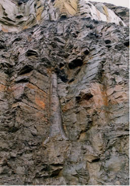
This is a good indication of the environment that existed here 300 million years ago, when the Penistone flags were first deposited. This is a tropical Lepedodhendron plant that would have grown in the swampy areas between river channel on a delta, much like the Ganges of Mississippi deltas of today. In fact all the rocks you find in West Yorkshire were deposited in one of the diverse depositional faciesthat you find in a detaic system.
This quarry is also important, as it supplied the stone for the guide stoops you will see on these walks.
Continuing onwards back down into the village, you will walk past the bottling plant of Shepley Spring, which is situated here because of a natural spring that (like many of the local springs) emerges from beneath the impermeable Greenmoor sandstone.
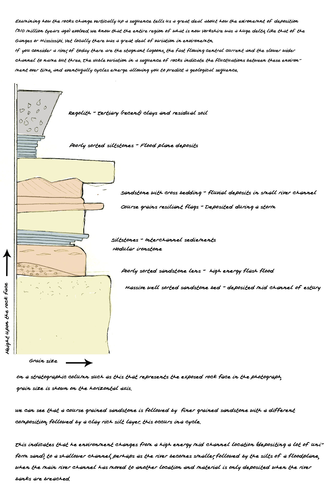
Up through the village and over the railway line, you will eventually come to the appropriately named Stone Wood, as there is a large abandoned Greenmoor sandstone quarry in the centre of this wood. The quarry has been temporarily surrounded by barbed wire, but you can still find excellent views of the huge weathered rock faces in this remote location. If you study this rock face and examine the changes in bedding width, grain size, mineral content, and thecementationbetween sand grains, you can determine how over time the environment of deposition fluctuated within the delta system. We annotate this in a geological log:
Crossing back over the railway line and continuing Southward, you will eventually come to a ridge covered in shrubs that overlooks Holme Valley. This excellent vista is a product of a resilient sandstone ridge that has withstood erosional forces acting on the rest of the valley. The lithology of this sandstone can be seen in the numerous small exposures of rock that can be found along the path. This is a good place to scrutinize the flaggy sandstone close up, and see how it is durable yet has a jointing system at a very specific inclination, and a flat regular horizontal bedding plane. You can then look into the distance to see how these properties of the sandstone have influenced themorphologyof the regional landscape.