Learn how the landscape was shaped in Farnley Tyas
This circuit, to the North and West of Farnley Tyas is a route filled with spectacular views, particularly of Castle Hill and The Victoria Tower, which can be used as a gauge of your own altitude as you traverse the hills and valleys.
As you see different rock types exposed at different heights, you can begin to construct a geological column for the area, that represents the progressive deposition of material in a delta that existed here 310 million years ago. We start on Thurstonland Road just outside of Farnley Tyas to the West. This position lies on the very resilient Grenoside sandstone which consists of thinly laminated beds of fine grained material, which can be found in the older local dry stone walls.
You can see this rock exposed in a quarry to the left as you walk along Ludhill Lane. This unit is up to 20 meters thick and accounts for the plateau on which Farnley Tyas has been built to ensure stability, and a vantage point over the surrounding land. This is the highest rock (and therefore least old) that you walk over today. As you walk down Ludhill Lane you will see another small exposure; a dark shale that is typical of a marine environment, yet now sits at 243m above sea level.
Throughout the last 300 million years since this material was deposited in a tropical marine environment, the shale has been uplifted in a mountain building orogenic event (responsible for the formation of the Pennines) and has migrated away from equatorial latitudes through the tectonic process of continental drift. The next exposure can be found as you walk over Ludhill Dyke, where in winter you can see numerous small springs converging into a deep valley. The flaggy sandstone rock that you can see here, exposed by the waterfall belongs to the Greenmoor Rock (203m asl). This rock has been deposited above sea level on a delta top, yet sits below the marine shale you saw earlier. This indicates that the environment of deposition at the time had dramatically changed. You might be able to see that in this deep valley, the bedrock is a much softer mudstone. The next exposed geology you will find is just off Honey Road. This position is around 210m above sea level, and although you have been uphill, we can determine that this rock is from the same unit as the flaggy Greenmoor found earlier, and hence of a similar age. There is a flaggy fine grained sandstone to the left, and an adjacent wall that looks almost the same as the natural rock face. This demonstrates how ideal the dense and flat Greenmoor flags are for this purpose, with such flags being used to construct the network of dry stone walls throughout Yorkshire when the enclosure acts were established in the 1700s.
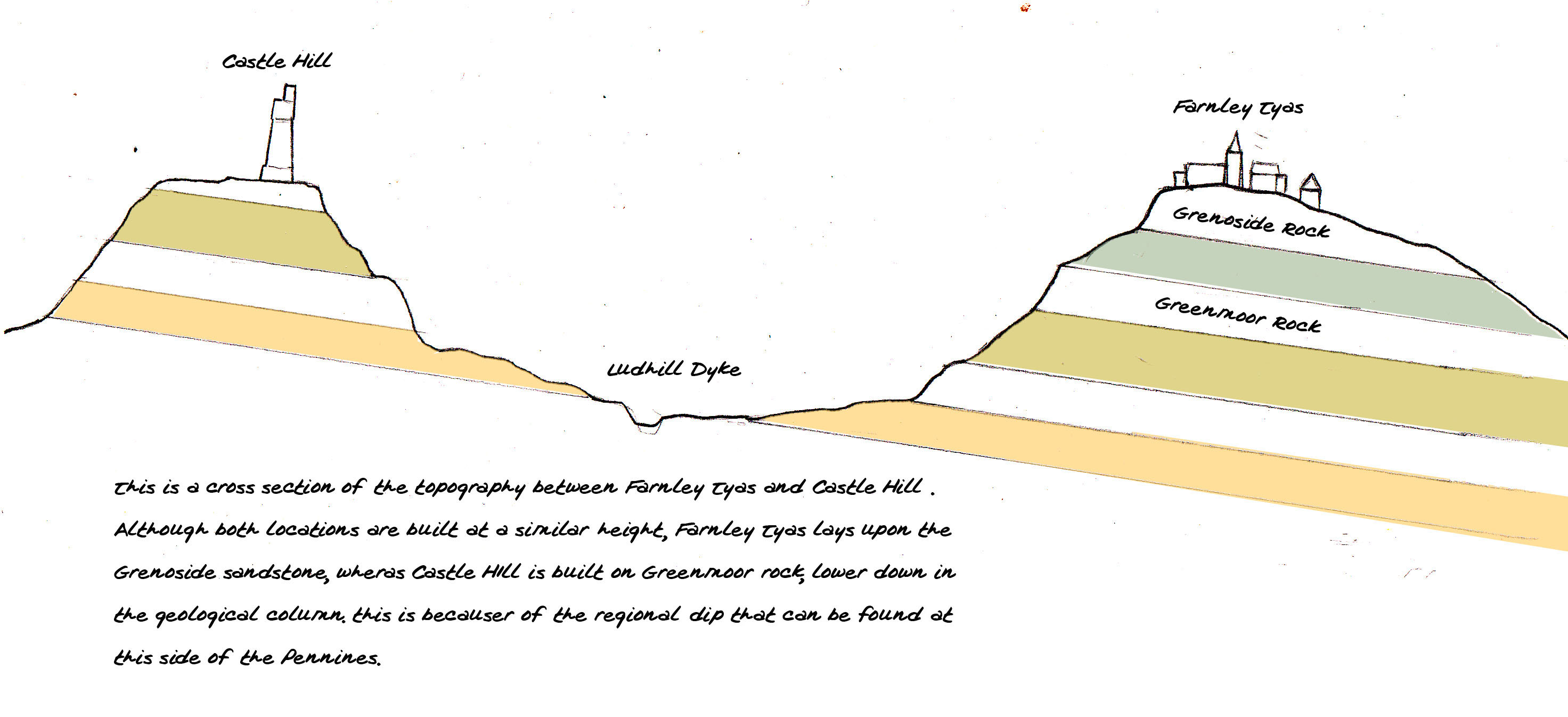
As you walk over Lumb Dike in the woods, you will notice that the river has exposed a very dark rock; a thinly layered or laminated shale, laying at a height of 160m. This locality is ideal for exploring the exposed shale and how the bedrock has affected the shape of the river, but be careful in bad weather, should you decide to venture further up the stream. As a general rule, the finer the grain of the composite sediment in a rock, and the darker the colouration of the mineralogy, then the further from land a rock was deposited. Now walking towards Castle Hill to Lumb Lane, this is the nearest you will come to the Victoria Tower, which was the location of an iron age fort, and has seen mining activity since the Roman times. It is clear why this hill is ideal for a vantage tower, utilising the natural properties of the flat and stable Yorkshire Sandstone. At the deepest point of the walk you will find exposed the 80 yard rock sandstone as you cross back over the stream in Molly Carr woods. This lithology is not shale however, but a weak siltstone that has been weathered by the river and cleaves easily, allowing you to look for fossils of Dumbarella or Carbonicola between the layers. This is the last exposure of the walk, and if you think about the heights and rock types you have seen, you can start to develop a geological model for the area. Here is a generalised cross section below: